Ireland map posters, historical Irish maps

Vintage Ireland map posters, historical Irish & Ancient world map wall prints. To enlarge or purchase securely online - click on images. These vintage Ireland map prints & wall posters are brought to you in affiliation with Zazzle.com. All transactions are safe & secure with satisfaction guaranteed.
Ireland vintage physical map poster.
Historical 1880 Ireland map poster
Ireland Map
1880. Wall poster.
32 Counties historical Irish map.
Historical Irish map print with 32 Counties of Ireland
Ireland Counties
map.
Historical Irish map print with 32 Counties of Ireland (1827).
Antique Ireland map poster.
Historical Ireland map poster 1799
Ireland provinces
1799 map poster.
Historical Ireland Provinces & Irish counties map 1799.
Historical map of Ireland, wall poster
Historical Ireland map
poster.
Featuring coat of arms & Irish county emblems.
Ireland topographic map poster
Topographic map
of Ireland.
Poster map of Ireland
Ireland poster map.
John Tallis Irish map poster 1851.
Illustrated antique Irish map print 1851
Map of Ireland
1851.
Illustrated old Irish map created by John Tallis in 1851, from History of Ireland by Thomas Wright.
City of Dublin 1797.
Dublin map print by John Speed 1797
Dublin Map
1797.
City of Dublin print by John Speed 1797, engraved by Jodocus Hondius.
Vintage British Isles wall map chart.
Vintage Map of British Isles 1631
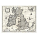
British isles
1631 Blaeu.
Europe 1721 map print
Vintage Europe
1721 map.
Wall poster.
Ferando Berteli 1565 world pictorial map.
Antique world pictorial map poster by Ferando Berteli 1565
Ancient World
map 1565.
Ancient world pictorial map by Ferando Berteli 1565. Includes sea creatures & mythical Isle of Hy Brasil in Atlantic ocean, off the Irish coast. Large wall poster. Digitally restored from LOC original.
Antique Britannia 17th century map poster
Britannia

Antique Great Britain 17th century Britannia map poster.
Colton Mercator Projection 1855 world map wall poster
Mercator Projection
1855.
Antique world map - Colton Mercator Projection 1855, wall poster
Illustrated antique world map poster 1886
Antique World Map
1886.
Illustrated world map poster.
Antique world map poster, J van Loon c1666

Old World Map
c1666.
Vintage print by J van Loon [c1666].
https://irelandposters.com/maps/Old World 1630 map poster
Old World
1630.
Wall print.
Old World Map with heavenly bodies - antique poster
Old World Map.

Heavenly bodies antique print.
17th century celestial map poster
Celestial map
17th Century.
Antique celestial map, 17th century.
Carta Marina, Ancient sea creatures of the world, wall poster
Carta Marina.
Antique wall chart depicting ancient sea creatures of the World, Carta Marina print.
Antique 1597 map of the Americas
Americas map
1597.
Vintage illustrated world map 1597 featuring the Americas. Includes South & Central America, Pacific & Atlantic Oceans. In the four corners are explorers reading maps and helping ships navigate the world. Artist: Theodor de Bry.
Antique 1595 Arctic continent, North Pole map poster
North Pole
1595.
Antique map featuring a view from the North Pole including the Arctic Circle, ocean & surrounding continents. By cartographer Gerardus Mercator, 1595.
World maps including global ocean currents & world languages wall chart : World map posters.

View pictures of famous landmarks & historic Irish monuments in Dublin city. Includes location information.

Rural Irish images including Kilkenny, Killarney & Connemara, Co. Galway. Vintage Ireland black & white prints.

Vintage Ireland travel prints & Irish railway posters, CIE Ireland bus tour postcard, Connemara Galway - Great Western Railway print.
 
19th century Ireland towns & landscape scenery : Antique Irish prints.

County Clare fields & farmhouses, Irish country views & Dublin city landmarks - Irish postcards

Irish posters & Pictures of Ireland - main contents.

Privacy policy.
 
Map of Ireland jigsaw puzzle
Ireland Jigsaw
.
Irish jigsaw puzzle featuring map of Ireland.